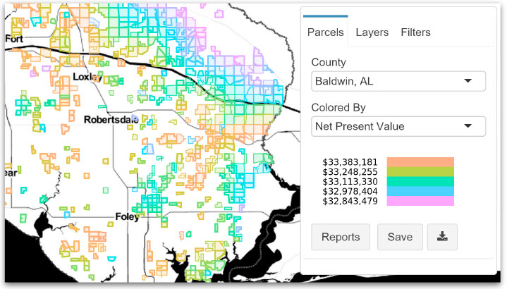
Smart Power Maps, a solution from recent The Butler Firm spinoff GeoCF LLC, enables users to comprehensively evaluate tens of thousands of potential ground-mounted solar projects simultaneously and supports project management for the best sites through all stages of development. With Smart Power Maps, solar developers can easily find high-value sites and bring them to market faster than ever before.
Finding the Shiniest Places with Shiny
Written by Chris Holcomb, Co-founder and CTO, GeoCF Smart Power Maps

"The challenge was to not only choose a productive software stack for me but one that could underlie our company’s value of bringing data from the analyst’s desk into an easy-to-use web application.”
Chris Holcomb
Co-founder & CTO, GeoCF Smart Power Maps
The Challenge
When Chris Holcomb, Co-founder and CTO of GeoCF, helped launch the company from inside the Butler Firm in 2014, he knew – as the sole developer in the beginning – that he would need to wear many hats.
“Especially in the beginning, I needed to be able to act as data analyst, database architect, web programmer, and designer. The challenge was to not only choose a productive a software stack for me, but to choose one that could underlie our company’s value of bringing data from the analyst’s desk into an easy-to-use web application.”
The Solution
It wasn’t the first time Chris faced this challenge. He had used R for data analysis of solar projects before and subsequently found a job at a solar consulting firm by demoing a Shiny application that analyzed a homeowners’ future bills based on housing characteristics and historical weather. He had confidence that the RStudio IDE and packages including shiny, dplyr, ggvis, tidyr, Rcpp, leaflet and stringr would help build the application he envisioned. Posit Connect was chosen as the production-quality deployment server.
Why Posit?
The growing team at SmartPower Maps believed, due in part to Posit’s development and support of open source tools, that R had the breadth and depth of capabilities they needed and was only getting better.
“I came from a C# background so I was unfamiliar with R and Shiny. However, I was able to quickly ramp up and now see it as a solution for teams that want to iterate quickly and build data-driven applications. The features in the Pro version help us manage and secure our software,” said Zhongxia Li, Lead GIS Sofware Engineer at GeoCF.
The Payoff
Smart Power Maps customers can easily find high value sites and bring them to market faster than ever before. Investors and financiers can quickly screen projects and calculate revenue potential, and engineering consultants can perform in-depth constraints analysis without special training or field research. Individual users or designated teams can manage every step of the solar development and evaluation process using a single, common tool, drastically reducing the time and effort required to work with disparate information that’s often on different platforms.
GeoCF LLC in Austin Texas is now a company that is growing and was recently awarded a $750,000 cooperative award from the U.S. Department of Energy’s SunShot Initiative.